
Gettysburg Off The Beaten Path
Not Just Any Hotel – Only the Best Gettysburg Off The Beaten Path, Selected for You!
Jun 17, 2026 - Jun 18, 2026
2 adults, 1 room
Find


Good
(1920)
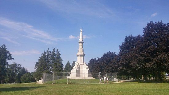
Gettysburg National Cemetery
Open 24 hours
Cemetery
Gettysburg National Cemetery (Baltimore Pike)
View map
Gettysburg National Cemetery is a cemetery for Union soldiers who died in the Battle of Gettysburg during the American Civil War. It is the site of President Abraham Lincoln's famous Gettysburg Address, where he honored the fallen soldiers and spoke about the nation's purpose.
Duration: approx. 1-2 hours
Free


Good
(226)
Evergreen Cemetery
Open all day
Cemetery
799 Baltimore St
View map
Evergreen Cemetery is a historic 29.12-acre rural cemetery located near Gettysburg. It was previously known as Citizen's Cemetery and Ever Green Cemetery, and it holds significant historical importance, especially related to the Battle of Gettysburg.
Duration: approx. 1-2 hours
Free


Good
(61)
Daniel Lady Farm
10:00 AM-5:00 PM
Farm
986 Hanover Rd
View map
Daniel Lady Farm is a historic site linked to the American Civil War. It played a key role during the Battle of Gettysburg, serving as a location for soldiers and medical care.
Duration: approx. 1-2 hours
Free